The second most popular and indeed one of the most beautiful routes up the mountain is the Machame Route. Also known as the Whisky Route, this trail is both longer and slightly more challenging than the Marangu Route. Where accommodation on the Marangu route is in huts, the Machame route offers strictly tents only. The route is better suited to the slightly more adventurous hiker, however rewarding him with a scenic splendor such as not seen on the Marangu route. Provided of its challenge about 80% of hiker makes to the summit of Africa.
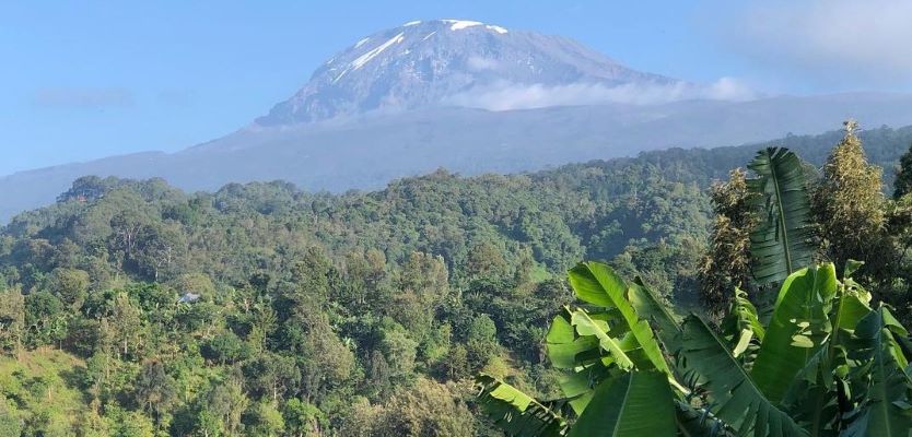
How to reach there: Transfer from you hotel and drive from Moshi to Machame gate which takes about 45 minutes passing the Machame village which cultivate bananas and coffee
Day 1: Drive to Kilimanjaro National Park Machame Gate, Hike to Machame Camp
Drive from Moshi to the Mount Kilimanjaro National Park Gate takes about 45 minutes. The journey passes through the village of Machame which is located on the lower slopes of the mountain.
We depart the park gate and walk through the rain forest on a winding trail up a ridge. At lower elevations the trail can be muddy and slippery. Gaiters and trekking poles are a good idea here. We continue a short distance until we reach the Machame Camp.
Elevation: 1830m/6000ft to 3050m/9950ft
Distance: 11km/7mi
Hiking Time: 5-6 hours
Habitat: Montane Forest
Day 2: Hike Machame Camp to Shira Camp
After breakfast we leave the glades of the rain forest and continue on an ascending path, crossing the valley along a steep rocky ridge. The route now turns west onto a river gorge until we arrive at the Shira campsite.
Elevation: 3050m/9950ft to 3850m/12,600ft
Distance: 5km/3mi
Walking Time: 4-5 hours
Habitat: Moorland
Day 3: Hike Shira Camp to Lava Tower to Barranco Camp
From the Shira Plateau we continue to the east up a ridge, passing the junction towards the peak of Kibo. As we continue, our direction changes to the South East towards the Lava Tower, called the “Shark’s Tooth” (elev 4650m/15,250ft). Shortly after the tower we come to the second junction which goes to the Arrow Glacier. We now continue down to the Barranco Camp. Although you end the day around the same elevation as when you began, this day is very important for acclimatization and will help your body prepare for summit day.
Elevation: 3850m/12,600ft to 4000m/13,000ft
Distance: 10km/6mi
Walking Time: 5-6 hours
Habitat: Semi-desert
Day 4: Hike Barranco Camp to Karanga Camp
After breakfast, we leave Barranco and continue on a steep ridge up the Barranco Wall to the Karanga Valley and the junction which connects with the Mweka Trail.
Elevation: 4000m/13,000ft to 4050m/13,250ft
Distance: 5km/3mi
Hiking Time: 34 hours
Habitat: Alpine Desert
Day 5: Hike Karanga Camp to Barafu Camp
We continue up to the Barafu Camp. You have completed the South Circuit, which offers views of the summit from many different angles. Here we make camp, rest, enjoy dinner, and prepare for the summit day.
Elevation: 4050m/13,250ft to 4700m/15,350ft
Distance: 4km/2mi
Hiking Time: 3-4 hours
Habitat: Alpine Desert
Day 6: Hike Barafu Camp to Summit, down to Mweka Camp
Very early in the morning (midnight to 2 am), we continue our way to the summit between the Rebmann and Ratzel glaciers. You head in a northwesterly direction and ascend through heavy scree towards Stella Point on the crater rim. This is the most mentally and physically challenging portion of the trek. At Stella Point you will stop for a short rest and will be rewarded with the most magnificent sunrise you are ever likely to see. Faster hikers may view the sunrise from the summit.
From Stella Point, you may encounter snow all the way on your 1-hour ascent to the summit. Once at Uhuru Peak you have reached the highest point on Mount Kilimanjaro and the continent of Africa!
From the summit we begin our descent by continuing straight down to the Mweka Camp, stopping at Barafu for lunch. You may want gaiters and trekking poles for the loose gravel going down. We arrive at Mweka Camp and enjoy our last evening on the mountain.
Elevation: 4700m/15,350ft to 5895m/19,340ft
Down to 3090m/10,150ft
Distance: 5km/3mi up / 13km/8mi down
Hiking Time: 5-7 hours up / 5-6 hours down
Habitat: Stone scree and ice-capped summit
Day 7: Hike Mweka Camp to Mweka Gate, drive to Moshi
After breakfast we continue the descent down to the Mweka Park Gate to receive your summit certificates. At lower elevations, it can be wet and muddy. Gaiters and trekking poles will help. Shorts and t-shirts will probably be plenty to wear (keep rain gear and warmer clothing handy).
Twende Africa Tours vehicle will meet you at Mweka gate to drive you back to your hotel in Moshi (about 30 minutes).
Elevation: 3090m/10,150ft to 1680m/5500ft
Distance: 10km/6mi
Hiking Time: 3-4 hours
Habitat: Forest